
Waimoku Falls via Pipiwai Trail: The One Hike You Cannot Skip on the Road to Hana
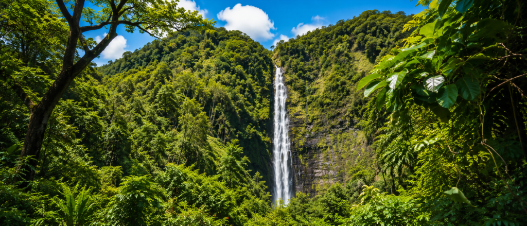
If you’re planning a Road to Hana adventure and wondering which stops deserve your limited time, I can tell you from guiding this route for years: Waimoku Falls via Pipiwai Trail is the one hike you absolutely cannot skip. I’ve walked this trail dozens of times with guests from Exclusive Hana Tours Maui, and it stays the most rewarding waterfall hike on the island.
This trail gives you a full sensory experience through one of Maui’s most diverse landscapes. If you treat it like a quick checkbox, you’ll miss everything that makes it unforgettable.
What Sets Pipiwai Trail Apart from Every Other Waterfall Hike
Most waterfall hikes on Maui follow a predictable formula: park your car, walk ten minutes on a paved path, snap a photo, get back in your car. Pipiwai operates on an entirely different level.
This is a 3.4 to 4-mile round-trip trail that takes you through many distinct ecosystems. You’ll pass two major waterfalls, cross wooden bridges, walk elevated boardwalks, and move through a bamboo forest so dense it creates its own weather system.
The trail gains about 700 to 800 feet in elevation, with most of that happening in the first steep section.
Plan for two to four hours depending on how often you stop to take in your surroundings.
The layered nature of this trail makes it unique. You start in a banyan grove where twisted roots create natural archways.
Then you pause at an overlook for Makahiku Falls, a 200-foot cascade that changes personality with the weather.
The trail continues through muddy rainforest terrain where tree ferns tower overhead and moss covers every surface. Eventually you walk under a canopy of bamboo that creaks and sways in the wind, creating sounds you’ll remember long after you leave.
Finally, you stand in front of Waimoku Falls, a 400-foot cascade that drops down a sheer lava cliff in a delicate veil of white water.
Each segment feels distinct. The variety keeps the hike engaging even for people who normally get bored on long walks.
You’re not just hiking to see one waterfall and calling it done.
You’re moving through chapters of landscape that each tell a different story.
The trail sits in the Kipahulu District of Haleakalā National Park, about 10 to 12 miles south of Hana town near mile marker 42. This section of the park feels completely different from the summit district.
Where the summit is dry, windswept, and volcanic, Kipahulu is coastal, lush, humid, and deeply connected to Hawaiian cultural history.
The streams here respond immediately to rain, and the forest grows thick and green year-round.
You’ll access the trail from the Kīpahulu Visitor Center, where you’ll pay the $30 per vehicle national park fee. This same pass also covers entry to the Haleakalā summit for several days, so hold onto your receipt if you’re planning to catch sunrise at the crater.
That First Steep Climb Will Test You (But It Gets Better)
I always warn my guests that the first half-mile to three-quarters of a mile is the hardest part of the entire hike. This section gains most of the elevation, and the trail surface becomes a challenging mix of dirt, exposed roots, volcanic rocks, and occasional muddy patches that stay slick even on sunny days.
If you showed up in flip-flops or smooth-soled sneakers, you’ll regret it within five minutes. The terrain demands traction.
The humidity makes even a short climb feel more taxing than you’d expect at sea level.
Your heart rate will climb, your breathing will quicken, and you’ll start to wonder if the whole trail maintains this intensity.
Here’s what I tell people who start to struggle: if you can push through this first segment, the rest of the trail eases up considerably. I’ve watched countless hikers turn around within the first ten minutes because they assume the entire hike will be this steep and relentless.
They miss the bamboo forest, they miss Waimoku Falls, and they leave thinking Pipiwai is overhyped.
The initial climb acts as your entry fee into the more magical sections ahead. Once you crest that first steep section, the grade mellows out.
You’ll still gain some elevation, but it happens gradually enough that you barely notice.
Your breathing returns to normal. You can start looking around instead of staring at your feet.
The forest closes in overhead, the temperature drops a few degrees, and you realize you’ve entered a completely different zone.
Makahiku Falls Teaches You About Variable Water Flow
About 0.5 miles in, you’ll reach a wooden overlook platform for Makahiku Falls. This spot gives you a chance to catch your breath and witness something that surprises most first-time visitors: waterfall flow changes dramatically based on recent rainfall.
Depending on what weather passed through in the last 24 to 48 hours, Makahiku can be a powerful, wide cascade throwing spray across the entire viewing platform, or it can trickle down in modest ribbons. Both versions are beautiful, just in different ways.
I use this stop to explain how Kipahulu’s stream systems respond almost immediately to rain. The waterfalls here don’t get fed by massive reservoirs or snowmelt from distant mountains. They run on rainforest runoff, which means what you see today might look completely different next week or even tomorrow.
This variability makes every trip feel unique. Some days Makahiku thunders so loudly you have to raise your voice to be heard.
The mist soaks your shirt and your camera lens gets spotted with water droplets.
Other days the falls whisper quietly, and you can hear individual streams trickling over rocks in the pool below. Both experiences teach you something important about how fragile and responsive these ecosystems are to rainfall patterns.
The viewing platform sits back from the falls for safety reasons. Flash floods can happen here with shocking speed when heavy rain hits the watershed above.
The forest can funnel water into these streams faster than you’d think possible.
I’ve seen streams go from ankle-deep to chest-deep in under an hour. The park service knows this, which is why they keep visitors at a safe distance and post flood warning signs at every stream crossing.
The Bamboo Forest Creates an Otherworldly Experience
After Makahiku, the trail continues through more rainforest. You’ll cross a couple of wooden bridges over streams that carve through volcanic rock.
The canopy thickens overhead, and the light turns green and diffused. Tree ferns unfurl in layers, creating a prehistoric atmosphere.
And then, almost without warning, you step onto an elevated boardwalk and enter the bamboo forest.
This section is what guests talk about most often, even more than the final waterfall. The bamboo grows so densely on either side of the boardwalk that it forms a natural tunnel.
The stalks arch overhead, blocking out most of the sky.
The air feels cooler and stiller here. When the wind picks up, the bamboo clacks and creaks, creating sounds that are both musical and slightly eerie.
I tell people to pause in the middle of this section, close their eyes, and just listen. The bamboo forest becomes a natural sound bath.
The hollow stalks knock against each other in rhythms that change with the wind.
You can hear individual leaves rustling. Occasionally a gust creates a wave of sound that travels down the tunnel.
Opening your eyes after listening for a minute or two makes the visual experience even more intense.
The boardwalk exists for important ecological reasons beyond making the trail easier to walk. This structure protects the forest floor from the thousands of feet that pass through here every week.
Without the boardwalk, erosion would destroy the delicate root systems and understory plants that keep this section healthy.
The boards distribute weight and keep foot traffic from compacting the soil.
The design shows how trail infrastructure can balance access with conservation. You get to experience this incredible environment without destroying it in the process.
The park service has to constantly maintain these boardwalks because the humid environment rots wood quickly.
They replace sections every few years to keep the structure safe and stable.
One critical safety note: the boardwalk gets slippery when wet, which in a rainforest means it’s slippery almost always. Walk carefully, especially if it rained recently.
The boards develop a coating of moisture and algae that makes them slick.
I’ve seen people go down hard because they were moving too fast or not paying attention. Take your time through here.
The bamboo forest deserves slow appreciation anyway.
The bamboo itself raises interesting ecological questions. Bamboo is not native to Hawaii.
Someone introduced it decades ago, and it spread aggressively.
Some ecologists worry about how it affects native plant communities. Others point out that the bamboo forest has become such an iconic part of the Pipiwai experience that removing it would disappoint thousands of visitors annually.
The park service has to balance these competing concerns while managing the landscape for both ecological health and visitor experience.
The Final Approach to Waimoku Falls
Once you emerge from the bamboo tunnel, the trail continues through a mix of open and forested sections. The path rolls gently with a few more stream crossings and stone steps.
You’ll know you’re getting close when the sound of rushing water grows louder and the trail funnels into a narrower gorge.
The vegetation changes slightly as you enter the amphitheater-like basin at the base of the falls.
And then you see it. Waimoku Falls drops 400 feet down a sheer black lava cliff.
The water free-falls most of the way before breaking into mist near the bottom.
The surrounding greenery makes the whole scene look like something from a fantasy novel. Ferns cling to the cliff face.
Moss covers every surface.
The scale is genuinely breathtaking.
No matter how many waterfall photos you’ve scrolled through on Instagram, Waimoku in person hits differently. The height is hard to process.
You have to tilt your head back to see the top.
The sound fills the entire basin. On sunny days, light catches the mist and creates shifting rainbows. The whole experience feels almost overwhelming in the best way.
Here’s where I need to get serious about safety. The base of the falls is roped off, and you’ll see very clear “No Swimming” signs posted. These warnings exist because rocks fall from that cliff without warning, and people have died here.
The danger doesn’t come from the water or strong currents.
The danger comes from gravity and geology.
The cliff face is constantly weathering. Water seeps into cracks in the volcanic rock, freeze-thaw cycles widen those cracks, and eventually chunks break loose.
Sometimes a rock the size of a basketball falls.
Sometimes it’s the size of a refrigerator. You cannot forecast when this will happen.
A sunny day with calm conditions won’t protect you from a falling boulder.
The safest view, and honestly the most beautiful view, is from the marked viewing area about 50 feet back from the base. This distance gives you a full perspective of the waterfall’s height and the surrounding cliff.
You can see the entire cascade from top to bottom.
You can photograph yourself or your group with the full scale of the falls in the background.
I frame it this way for my guests: the best photo captures the scale and drama of Waimoku. That means showing tiny human figures against the massive waterfall, not a close-up selfie that doesn’t convey the grandeur of the place.
Stepping closer might feel tempting, but it gives you a worse shot and puts you in serious danger.
Timing Your Hike and Understanding Seasonal Conditions
When I plan a Pipiwai hike for my guests, I aim for an early start. Being on the trail by 8:00 or 9:00 AM means cooler temperatures, fewer crowds, and better light for photography.
The trail is technically open all the time, but the visitor center operates roughly from 9:00 AM to 5:00 PM, and hiking in daylight is always safer and more enjoyable.
The best overall conditions tend to happen between April and October, which counts as the drier season. I put “drier” in quotes because this is still a rainforest.
You can absolutely get sudden showers even in the dry season.
But the trail is usually less muddy, the streams are safer to cross, and you have more predictable weather patterns.
During the wetter winter months from November through March, mud becomes a serious factor. The first steep section can turn into a slick obstacle course.
Stream crossings get deeper and faster.
Flash flood risk increases significantly. I pay close attention to posted signs and ranger advisories during this time.
If conditions look questionable, we adjust the plan or skip the hike entirely.
One of the most common mistakes I see happens in the parking lot before people even start hiking. They packed for a beach day and then decide to tackle Pipiwai in beach clothes and flip-flops.
This approach guarantees misery.
You need sturdy closed-toe shoes with good traction. Trail runners work well.
Light hiking boots work well.
Flip-flops or smooth-soled sneakers will have you sliding all over the place.
You need enough water for at least two to three hours of hiking in humid conditions. I recommend at least a liter per person, more if it’s hot or you hike slowly.
There’s no water source along the trail.
The streams you cross are not safe to drink from without filtration.
You need sunscreen for the exposed sections, particularly that first climb. You need insect repellent for the mosquitoes that thrive in wet, shaded areas.
A lightweight rain jacket is smart even on a sunny day because weather can change fast.
I’ve been soaked by sudden showers that lasted ten minutes and then cleared completely.
The Pi’ilani Highway and Changing Access Routes
One piece of recent news that’s changed how I plan trips is the reopening of the Pi’ilani Highway, the “backside” route that runs south of Hana and provides an alternate way to reach Kipahulu. After more than a year of closure because of weather damage and deteriorating road conditions, it reopened in 2025.
On days when it’s safe and rental car companies allow it, the backside route offers a quieter, less trafficked approach compared to the traditional Hana Highway.
The backside route needs some context. The road is narrower and less developed than the main Hana Highway.
You’ll drive through remote ranch land with minimal services.
Cell service is spotty to nonexistent. The pavement quality varies, and some sections are rough enough that rental car companies sometimes restrict access.
For guests who want a different rhythm to their day, or who are starting from the south side of the island near Wailea or Kihei, the backside route can be a viable option. It cuts out some of the Hana Highway traffic and gives you a completely different landscape to look at.
But I always check current road conditions before committing to this route, and I make sure everyone understands the tradeoffs.
Cultural Context and the Meaning of Place Names
As we hike, I try to weave in the Hawaiian language and cultural history that give this place meaning beyond its physical beauty. The name Pipiwai, the name Kipahulu, the name ‘Ohe’o, these carry significance beyond being labels on a map.
They’re part of a living language and a living relationship to the land.
‘Ohe’o Gulch, often called the Seven Sacred Pools in tourist literature, carries a deeper significance than the marketing nickname suggests. The modern phrase was invented to attract visitors, but the gulch itself has a long history tied to traditional land use, fresh water access, and the relationship between upland streams and the ocean.
Walking the Kūloa Point loop near the visitor center, you can look out over the gulch and imagine how communities lived here, sustained by the water and the forest, long before the Road to Hana became a tourist route.
The Kipahulu District was an ahupua’a, a traditional land division that ran from the mountains to the sea. This design allowed communities to access all the resources they needed, from ocean fish to forest plants to mountain birds.
The streams flowing down from Haleakalā provided fresh water for drinking, irrigation, and connecting the upland and coastal ecosystems.
What Surprises First-Time Hikers Most
At the end of a Pipiwai hike, I like to ask my guests what surprised them. The answers are rarely what you’d expect.
Some people are blown away by the sheer height of Waimoku Falls, which photos don’t really capture.
Others are still thinking about the sound of the bamboo forest or the way light filtered through the canopy on that first steep climb. A lot of people are surprised by how much elevation they gained without really noticing it after the initial push.
One thing that consistently surprises first-timers is how much care goes into maintaining this trail. The boardwalks, the bridges, the signage, the erosion control structures, none of it is accidental.
Every element serves a purpose.
The trail represents years of planning and ongoing maintenance work to balance access with preservation.
You get to walk through a fragile rainforest because someone invested in infrastructure that protects the forest from being loved to death. Without these interventions, the trail would turn into a muddy erosion gully.
Plant roots would be exposed and damaged. Stream crossings would become unsafe.
The bamboo forest boardwalk would be a trampled mudpit.
Common Mistakes and How to Avoid Them
The most common mistake I see is people underestimating the trail. They hear “moderate” and assume it’s a casual stroll.
But moderate in a rainforest, with mud and humidity and elevation gain, can feel a lot harder than moderate on a dry, well-graded path.
If you’re not used to hiking, or if you’re bringing kids or older family members, build in extra time and be realistic about fitness levels.
Another big mistake is arriving too late in the day. If you don’t start the hike until 2:00 or 3:00 PM, you’re going to rush through it, and you’ll miss the chance to really absorb the experience.
Plus, hiking out in low light is risky, especially on the slippery sections.
Start early and give yourself plenty of daylight.
People consistently underestimate how much water they need. Even if it’s cloudy or drizzling, you’re going to sweat in the humidity. Your body loses moisture fast in these conditions.
Bring at least a liter per person, more if it’s hot or you tend to drink a lot when you exercise.
Don’t ignore the safety signs. The “No Swimming” warnings at Waimoku Falls exist because people have died there.
The flash flood warnings near stream crossings are based on real incidents.
The boardwalk caution signs are there because people slip and get hurt. This is a well-managed trail, but it’s still a wild environment that demands respect.
Frequently Asked Questions

How long does the Pipiwai Trail take to hike?
Most people take between two and four hours to complete the 3.4 to 4-mile round-trip trail. This includes time to stop at Makahiku Falls, walk through the bamboo forest, and spend time at Waimoku Falls.
If you’re a fast hiker who doesn’t stop much, you could do it in under two hours.
If you have kids, take lots of photos, or hike slowly, plan for three to four hours.
Can you swim at Waimoku Falls?
No. Swimming at Waimoku Falls is prohibited and extremely dangerous. Rocks fall from the 400-foot cliff without warning, and people have died there.
The danger comes from rockfall, not the water itself.
The best and safest view is from the marked viewing area.
What should I wear to hike Pipiwai Trail?
Wear sturdy closed-toe shoes with good traction. Trail runners or light hiking boots work well.
The trail has mud, roots, rocks, and slippery boardwalks that make flip-flops or smooth-soled sneakers unsafe.
Bring a rain jacket even on sunny days, and dress in layers you can adjust as you warm up from hiking.
Is Pipiwai Trail good for kids?
Families with kids who are comfortable hiking can enjoy this trail, but be realistic about your children’s fitness levels. The first steep section can be challenging for younger kids.
The total distance and time commitment might be too much for kids under 6 or 7.
Take extra time, bring plenty of snacks and water, and be prepared to turn around if needed.
When is the best time to hike Pipiwai Trail?
Early morning gives you cooler temperatures, fewer crowds, and better light. The drier months from April through October tend to have less mud and more predictable weather, though rain is always possible in a rainforest.
Avoid starting late in the afternoon when you might run out of daylight.
Do I need a allow to hike Pipiwai Trail?
You need to pay the $30 per vehicle Haleakalā National Park entrance fee at the Kipahulu Visitor Center. This same pass covers the summit district for several days.
No extra allows are required for day hiking.
How muddy is the Pipiwai Trail?
The trail can be quite muddy, especially in the first steep section and after recent rain. Even during the drier months, expect some muddy patches. The wet winter months from November through March tend to be muddiest.
Good traction on your shoes makes a huge difference.
Is the bamboo forest on Pipiwai Trail native to Hawaii?
No. The bamboo was introduced to Hawaii and is not native. It has spread aggressively in some areas.
The bamboo forest on Pipiwai Trail has become an iconic feature that enhances the hiking experience, though it does raise questions about balancing visitor experience with ecological management of native ecosystems.
Key Takeaways That Will Make Your Hike Better
The first steep climb is the hardest part. Once you’re past it, the trail eases up and the real magic begins.
Push through that first section and you’ll be rewarded with much easier terrain ahead.
The bamboo forest deserves slow appreciation. Pause in the middle, close your eyes, and listen to the sounds the wind creates through the hollow stalks.
This sensory experience is as memorable as any visual element of the trail.
Waimoku Falls is stunning from the safe viewing area. Getting closer doesn’t improve the view and puts you in serious danger from rockfall.
The best photos show the scale of the falls with people visible for perspective.
Start early to beat crowds and heat. Plan for two to four hours total.
Bring sturdy shoes with good traction, at least a liter of water per person, and respect all posted safety signs.
The trail rewards those who treat it as a full experience as opposed to a quick stop.